Managing additional Geometry Layers
ITS Multi-Plan can be used to manage additional geometry layers for sector-specific solutions and other data models. This is possible by implementing a flexible data model that documents geometry and attribute data for additional maps. By combining this product with ITS GeNSI®, it is possible to automatically generate additional overview maps.
- Additional maps are documented
- Flexible data model that can be used as an extension for any other model
- Managing geometry and attribute data
- Connecting objects within various maps
- Optionally, additional maps can be derived
Product Description
ITS Multi-Plan
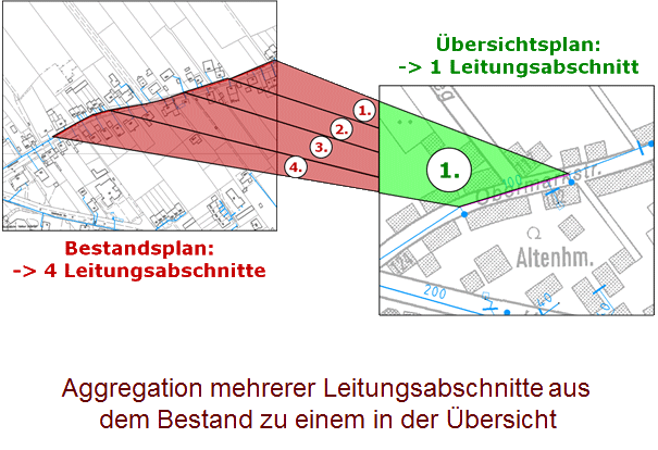
Overview maps are generated in ITS Multi-Plan using geometry fields of standardised sector-specific data models. Several overview maps can be created. Geometries are mapped for different scales and are incorporated into an independent data model. Objects to be displayed in the overview map are configured in a file.
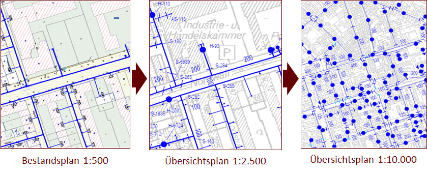
Overview maps are generated at scales of 1:2,500, 1:5,000, 1:10,000 and 1:20,000 without having to modify sector-specific data models. Another advantage of implementing ITS Multi-Plan is the universal structure, which can be used to integrate customer models. In the process, asset objects are always correctly linked and contain geometries and attribute data that can be used for analyses. The first step of generating overview maps with ITS Multi-Plan is to assign individual line sections to a higher-level line object through network tracing. During this process, attribute data of asset objects is aggregated into the new object. Newly generated ITS Multi-Plan data is related to asset objects it originated from. As a result, additional information can be accessed in maps by extending the object editor of sector-specific data models.