Homogenisation of Pipeline and Power Line Networks
In order to document the location of pipeline and power line networks, these are surveyed and then documented in a base map. Hoewever, occasionally the base map is modified or replaced by a new base map. With the product ITS LEHO®, the pipeline or power line network can be automatically adjusted for the new base map.
- Automatic location adjustment based on base maps
- Preserving original characterisitcs such as perpendicularity and angles
- Merging different base maps
- Integrating further maps (e.g. for planning)
- Switching from a raster base map to vector data
Product Description
Introduction
Generally, a pipeline or power line homogenisation means that the asset documentation including the relation to neighbouring objects is taken into accout when adapting the information to a new geodetic reference system. For example, this can be a switch from an individually created base map to the German ALK base map. With the product LEHO® by the ITS Informationstechnik Service GmbH, it is possible to automatically carry out a pipeline or power line homogenisation. ITS LEHO® can be installed as a standard module in Smallworld GIS and is designed as an independent data model that can be used for all types of sector-specific solutions.
Functionality
With ITS LEHO®, the location of assets is adjusted in relation to the location of the base map whilst taking relations of neighbouring objects into account. Geometry relationships between objects as well as base map objects are especially important. The homogenisation process of ITS LEHO® only affects the location of geometry objects. All topological relationships remain intact.
Areas of Application
Homogenising a network is necessary for different reasons. Below are some examples for some of the most frequent reasons:
- Switching from an individual base map to an official base map (e.g. ALK / ALKIS)
- Merging various network maps into a uniform base map (e.g. due to company mergers)
- Editing a network due to the inhomogeneneous geographic adjustment of a base map (e.g. homogenising by the cadastral office).
Functions
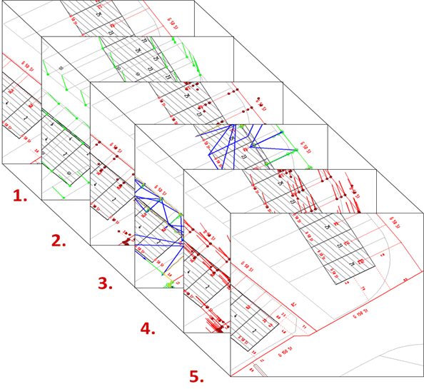
The pipeline or power line homogenisation in LEHO® is carried out in five steps:
- Search for identical points
- Defining displacement points
- Defining (detecting) geometric features
- Homogenisation calculation
- Executing adjustments
It is possible to define specific areas within the entire base map and to adjust these individually. The execution of these individual areas in ITS LEHO® is described in the following sections.
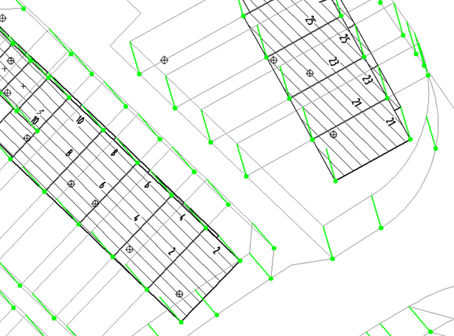
1. Searching for identical Points
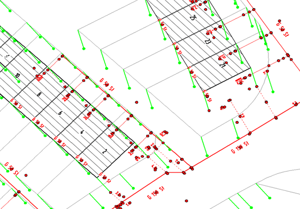
When searching for identical points, buidlings and boarders are often used as real world reference points in the old and the new geodetic reference system. By identifying these points, the vector displacement calculation is carried out. Furthermore, these newly calculated vectors are saved for evaluations and can be used for quality assurance in the map. Green vectors are displayed near buildings and boarders that were used to identify identical points. These vectors are the basis for the displacement calculation.
2. Defining Displacement Points
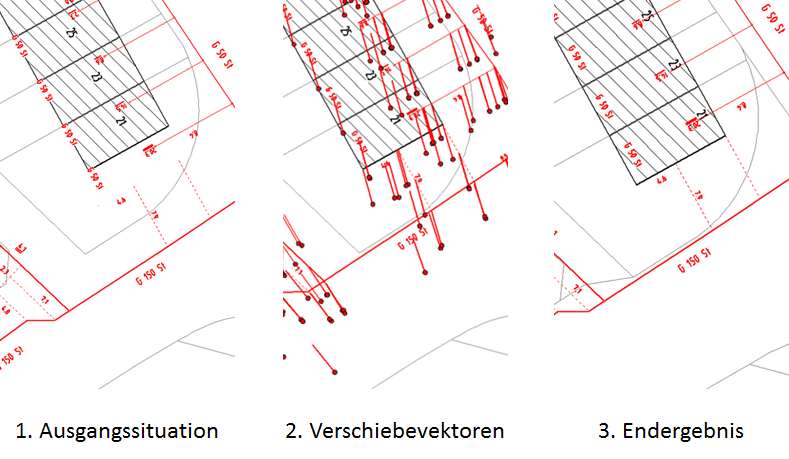
In the second step, all points (displacement points) that should be included in the homogenisation process are identified and marked. These include all of the support points for objects to be shifted i.e. pipeline or power line points, reference points of text labels, point objects as well as geographic dimensions. By shifting these points as well as neighbouring objects, the homogenisation process is executed. Points to be displaced are configured in a guided menu within ITS LEHO® at the start of the project. The figure shows affected points displayed in red.
3. Defining geometric Features
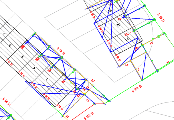
The third step includes the detection of geometric features. Characteristics of relationships between assets as well as base map obejcts (buildings, boarders) are identified automatically. For example, these could be parallel or perpendicular features that are important for map interpretations. Typical use cases for geometric features are the perpendicularity between pipeline connections and buildings or parallel power lines.
4. Homogenisation Calculation
Calculating the displacement whilst considering neighbouring relationships and preserving geometric features is the fourth step. Displacement vectors are calculated iteratively. Identical points and geometric features are known components whereas displacement points are unknown components. The homogenisation results are displayed using vectors in a Smallworld GIS graphic window (see figure with red vectors).
5. Executing the Homogenisation
In the fifth step, the homogenisation process is executed. Assets and geographic dimensions are displaced based on the new geodetic reference system. This is the only processing step where data in the sector-specific Smallworld GIS application is modified. All five processing steps can be carried out chronologically and automatically in one action. However, users can also check each step individually and intervene if necessary.
Conclusion
With the product LEHO® by the ITS Informationstechnik Service GmbH it is possible to homogenise pipeline and power line networks based on mathematical algorithms. These results are transparent and repeatable. Compared to manually processing a homogenisation, ITS LEHO® significantly reduces workload as well as costs. The product is fully integrated into Smallworld GIS, but can also be applied to other GIS products where an interface exists.