Quick Cartographic Dimensioning with Construction Lines
Constructive Dimensioning
The product ITS Constructive Dimensioning was specially developed for companies that prioritise quick and efficient cartographic dimensioning tools. As about 30%-50% of time and effort is spent on editing and documenting dimensions in detailed maps, this tool is very cost-effective.
- Creating cartographic dimensions easily and quickly
- Straightforward and efficient data model
- Optimised handling via the keyboard or mouse
- Numerous construction functions
- Integrated survey-specific calculations
Product Description
Constructive Dimensioning
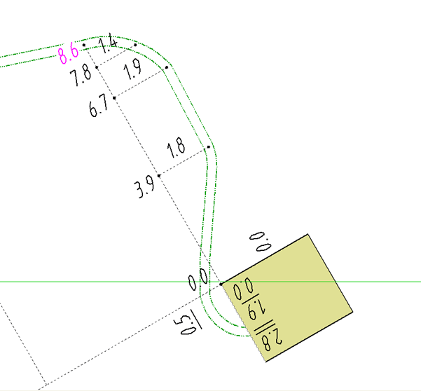
Cartographic constructive dimensioning is easy. A straightforward data model with standard Smallworld geometries (points, lines and texts) is implemented and can be used for all applications as well as sector-specific data models. In order to create cartographic dimensions, standard auxiliary lines and keyboard shortcuts are applied. These are configured in XML. A time-consuming differentiation between dimension types and status values is not required as only one line type with corresponding symbols such as right-angled, degree and arrow depictions is available. Furthermore, additional texts can be placed next to dimension numbers.
Editing Functions
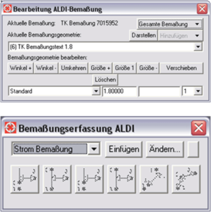
ITS Constructive Dimensioning is very versatile in regards to its functions. It is aimed at optimising editing work. Cartographic dimensions can be modified by shifting construction points using the standard Smallworld function “dynamic shifting”. With the help of efficient keyboard shortcuts and integrated intelligence, cartographic dimensions can be created and edited in just a few mouse clicks. To optimally edit dimensions, a separate editing menu is available for editing dimension texts directly in the main window. They can also be rotated, enlarged or diminished. Furthermore, additional geometries and texts can be created using this special editing menu.
Construction Functions
In order to optimally create cartographic dimensions, a range of construction functions are available. Through the click of a button, a computation of points is determined in a net of aligning bases including a compensation. Ordinates and abscissae can be typed into a graphic window. Points determined in a net of aligning bases can also be computed without compensation through the extension of an existing line (e.g. edge of a building). Afterwards, cartographic dimensions are supplemented with additional geometries. Furthermore, auxiliary lines can snap on all dimensioning construction points, for example, to edit pipelines. Alternatively, cartographic dimensions can be created based on exisiting construction points instead of new ones.